• Skip to primary navigation
  • Skip to main content
  • TTI Home
  • Aviation Research Home
  • Contact
Texas A&M Transportation Institute logo
Aviation Research
  • About
  • System Planning and Research
  • Aviation Education
  • Texas Aviation Conference
  • Publications
    • Wingtips
  • News

general aviation

Recently Completed Project Provides Guidance for General Aviation Airport Pavement Maintenance

October 18, 2016

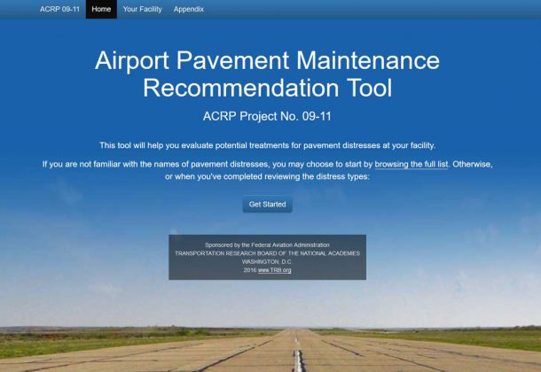
Airport Maintenance Recommendation Tool website screenshotThere is one thing all airports have in common—pavement—and a lot of it. In fact, pavements represent perhaps the largest expenditures at any airport. Thus, it is critical that airport management inspect and maintain their pavements for not only safety reasons, but to perform timely maintenance in order to avoid costly full pavement rehabilitation projects.

The Texas A&M Transportation Institute (TTI) recently completed a project, sponsored by the Airport Cooperative Research Program (ACRP), that provides guidance to general aviation airport managers in determining the most cost-efficient and appropriate preventative maintenance solution to common pavement issues.

“This project provides tools for general aviation airport managers to go out, walk the pavement and identify common pavement distresses,” says TTI Pavement Management Program Manager and Project Leader Tom Freeman. “These are general aviation airports we’re talking about and some of them are very small. The airport managers in most cases do not have experience in identifying when they have a problem with their pavement, what they should do, or they may wait too late to take action.”

The project results yielded four products: a report, guidebook, field guidebook and website. The TTI Communications group assisted the project team in developing the project resources.

“Key to this project was the production of deliverables that could easily be interpreted and used in the field,” notes TTI Research Scientist Jeff Borowiec. “The website and field guide allow a user to quickly determine what type of cracking or surface distress they may be looking at, and then the best course of maintenance action.”

One of the features of the website is a cost estimator tool that it is equally easy to use on a phone or tablet as on a desktop computer. For example, if a user sees a pavement distress, they identify it using pictures provided on the website. Then the user goes through a series of steps to determine the severity of the distress and best repair option. The user is then provided with a cost estimate that can be taken to local officials.

“I like to equate pavement maintenance with maintaining your vehicle,” says Freeman. “If you invest resources into keeping it in good shape, then it will save you costly repairs in the future. We hope the tools we’ve developed in this project assist airport managers in making key decisions.”

Project Resources

Field Guide for the Airport Pavement Maintenance Recommendation Tool for ACRP Report 159 (PDF)

Airport Pavement Maintenance Recommendation Tool (website)

Filed Under: Featured News Tagged With: ACRP, general aviation, pavement, pavement maintenance

General Aviation Pitches in During Texas Storm Recovery

June 1, 2016

By Dan Namowitz
Aircraft Owners and Pilots Association

View of Interstate 10 west to east at the Texas Travel Information Center (the Texas Welcome Center) in Orange, Texas. Photo by Yasmina Platt.

View of Interstate 10 west to east at the Texas Travel Information Center (the Texas Welcome Center) in Orange, Texas. Photo by Yasmina Platt.

When river flooding from violent storms shut down a major interstate highway in Texas and threatened to disable key public facilities in mid-March, general aviation pilots provided officials monitoring the situation with timely updates on the rapidly changing situation.

Different pilots and members of the Texas Wing of the Civil Air Patrol (CAP) flew dozens of missions and took thousands of digital photos in support of the emergency response. And in some cases, they found that the risks posed by the situation weren’t only on the ground.

“The State Operation Center uses the imagery for state response and mitigation planning by Texas Division Emergency Management, Texas Commission on Environmental Quality and Texas Department of Transportation,” the CAP’s Texas Wing said on its website.

The CAP was credited for doing “a great job of day-by-day documentation of changing conditions at key structures,” by Dr. Gordon Wells, program manager of the Center for Space Research at the University of Texas-Austin.

As a newspaper in Tyler, Texas, reported, some CAP pilots flying as low as 1,000 feet agl initially found themselves in the same airspace as numerous aircraft of various types, “‘from helicopters to ultralights,’” according to Maj. Steve Robertson, southwest region director of emergency services, that were not monitoring the same frequencies, but also pitching in. The profusion of traffic caused some CAP aircraft “to deviate from the intended flight route,” the paper reported. At the CAP’s request, the FAA imposed a temporary flight restriction for a portion of the recovery period. The TFR included unmanned aircraft in the flight prohibitions.

On March 17, the Weather Channel reported that the Sabine River dividing Texas and Louisiana crested at Deweyville, breaking “the unofficial highest river level set over 130 years ago” after a week of torrential rain. Mandatory evacuations, the flooding of hundreds of homes and numerous rescues were in progress as two reservoirs on the river overflowed. Along the border of Texas and Louisiana, the Weather Channel described the river’s flooding as “historic.”

South of Deweyville, the two-state area continued to be hard-hit.

“Interstate 10 was closed at the Louisiana/Texas border for at least four days,” said AOPA Central/Southwest Regional Manager Yasmina Platt, who monitored some of the continuing CAP flights’ radio reports as she flew herself from Orange, Texas, to Baton Rouge, Louisiana, to participate in a legislative hearing on March 21.

About one-third the length of I-10, which runs from Santa Monica, California, to Jacksonville, Florida, and is the southernmost major interstate highway in the United States, is within the state of Texas. The highway reopened on March 18 after waters receded.

Filed Under: Wingtips Spring 2016 Tagged With: general aviation, recovery, storm

  • The State of Texas
  • Texas Homeland Security
  • Texas Veterans Portal
  • State Expenditure Database
  • Statewide Search
  • State Auditor’s Office Hotline
  • TAMUS Risk, Fraud & Misconduct Hotline
  • Site Policies
  • Open Records Policy
  • Statutorily Required Reports
  • TTI Rules
  • Veterans
  • Equal Opportunity
  • COVID-19 Info
  • Jobs
Member of the Texas A&M University System

© 2023 Copyright Statement / Legal Notices and Policies

Comments, suggestions, or queries? Contact us!

Texas A&M Transportation Institute · 3135 TAMU · College Station, Texas 77843-3135

(979) 317-2000